Navigation and Map Reading Tips
What Is Map Reading and Why Is It Important?
Map reading isn’t just for seasoned explorers—it’s a skill that anyone spending time outdoors should have in their toolkit. Whether you’re planning a countryside walk, a mountain hike, or an off-the-beaten-track adventure, knowing how to read a map can make the difference between a brilliant day out and a stressful one. It’s all about understanding where you are, where you’re going, and what’s around you.
While GPS devices and smartphones are handy, they’re not foolproof. Batteries die, signals drop, and sometimes, technology just lets us down. That’s when knowing how to use a paper map and compass really comes into its own. It’s a bit like learning to ride a bike—once you’ve got the basics, you’ll always have the confidence to find your way, no matter what.
Getting Started: Essential Map Reading Skills
If you’re new to map reading, don’t worry—everyone starts somewhere! Here are a few basics to get you going:
- Get to know the symbols, scales, and the map’s legend (key). It’s like learning a new language, but much easier.
- Practice orientating your map so it matches the landscape you see around you.
- Try out grid references to pinpoint exactly where you are or where you want to be.
- Understand how to use a compass alongside your map.
Top Tip: Draw a simple map of your local area or jot down directions for a favourite walk, then try following them as if you’re seeing the place for the first time. You’ll quickly spot what helps and what confuses you—great practice for real adventures!
Cracking the Code: Map Symbols and Legends
Maps use symbols—rather than words—to show features like roads, footpaths, rivers, woods, and buildings. The map legend (or key) explains what each symbol means. Familiarise yourself with the legend before setting out, and refer to it often.
- Blue lines for rivers and streams
- Green areas for forests or woods
- Black lines for roads and paths
- Look out for icons showing campsites, viewpoints, car parks, and more.
Pro Tip: Ordnance Survey (OS) maps are the gold standard for UK outdoor adventures, offering a comprehensive legend and detailed information for walkers and explorers.
Decoding Map Scales and Types
Map scale tells you how much the real world is reduced to fit on the map. The most popular OS map scales are:
- 1:25,000 (Explorer Series): Highly detailed, perfect for walking, hiking, and off-path adventures.
- 1:50,000 (Landranger Series): Covers a larger area with less detail, ideal for cycling, running, or planning longer routes.
Choosing the right map:
- Use a more detailed scale for complex terrain or when navigating off established paths.
- Select a smaller scale for planning longer journeys or when you need an overview of a wider area.
How to Set and Orientate a Map
Orientating your map means aligning it so the features on the map match those on the ground—a fundamental step for accurate navigation.
To orientate your map:
- Hold the map so the top points north.
- With a compass: Place it on the map, rotate the map until the red needle points to the top (north), aligning it with the north-south grid lines.
- Without a compass: Use the sun’s position (east in the morning, south at midday, west in the evening) as a rough guide to direction.
Why orientate? It helps you visualise your route, identify landmarks, and make confident decisions at junctions or when visibility is poor.
Using a Compass: The Basics
A compass is your most reliable tool for finding direction and setting bearings, especially in unfamiliar or featureless terrain.
Key compass skills:
- Setting the map: Use the compass needle to align your map to north.
- Taking a bearing: Place the compass on the map, align its edge with your intended route, rotate the housing to line up with grid north, then turn your body until the needle aligns with the orienting arrow.
- Walking on a bearing: Follow the direction of travel arrow on your compass, checking your progress regularly to stay on course.
Tip: Master both traditional and digital compasses, but always carry a physical compass as a backup for safety.
Silva 1-2-3 System: Overview
If you want a foolproof way to use your map and compass together, the Silva 1-2-3 System is your new best friend. It’s a three-step method that makes navigation straightforward, even if you’re a complete beginner.
Once you’ve learned it, you’ll always have a reliable way to plot and follow a route—no matter the weather, visibility, or tech problems. In the next section, we’ll break down how the Silva 1-2-3 System works and why it’s a must-have skill for anyone who loves the outdoors.
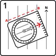

Place your compass on the map aligning the edge of the compass with the line of travel towards your destination.
Next, rotate the compass dial until N on the dial points North on your map, checking that the compass’ red/black North/South lines are parallel with the map’s meridians.
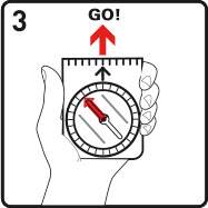
Holding the compass, turn your body until the red end of the compass needle points towards N (North) on the compass dial. The arrow at the front of the compass should now point towards your destination. Repeat this procedure until you reach your final destination.
Grid References: Pinpointing Your Location
Grid references are a precise way to communicate or record exact locations on a map, using the blue grid lines printed on OS maps.
How to find a grid reference:
- First, read the number along the bottom (eastings).
- Then, read the number up the side (northings).
- Combine them for a four-figure (general area) or six-figure (precise point) reference. For example: 3311.
Practical use: Grid references are essential for emergencies, route planning, and sharing locations with others
Reading Contour Lines and Landforms
Contour lines show changes in elevation and the shape of the land, helping you understand hills, valleys, ridges, and slopes.
Key points:
- Close contour lines = steep slopes
- Wide contour lines = gentle slopes
- Concentric circles = hills or summits
- V-shaped contours = valleys (the point of the V usually indicates upstream)
Learn the terminology: Hill, summit, knoll, ridge, spur, valley, saddle, col, convex slope, concave slope. Practise identifying these features both on your map and in the landscape
Measuring Distance and Estimating Time
Want to know how far you’ve got to go? Use the map’s scale bar or a ruler to measure straight lines, or a piece of string for twisty paths.
- For winding routes, lay the string along the path, then measure it against the scale.
- To estimate time, use Naismith’s Rule: allow about an hour for every 5km (3 miles) of walking, plus an extra hour for every 600m (2,000 feet) you climb.
Tech vs. Traditional: Navigating in the Modern World
GPS devices and mobile navigation apps offer convenience and extra features like live tracking and route recording, but they should never replace traditional map and compass skills.
Best practice:
- Use GPS for confirmation and as a backup.
- Always carry a paper map and compass, and know how to use them.
- Download offline maps and bring a spare battery pack if you’re relying on tech.
Common Map Reading Mistakes (and How to Avoid Them)
- Not lining up your map with the landscape—always orientate before you set off.
- Mixing up symbols or not checking the scale—take a moment to read the legend.
- Relying too much on technology—batteries die, so have a backup.
- Ignoring contour lines—underestimating hills can make a walk much tougher than expected.
- Not planning ahead—always check your route, note escape points, and have a plan B.
FAQs
Select a scale that matches your activity: 1:25,000 for detailed walking, 1:50,000 for broader coverage or cycling.
Start with familiar routes, practise with friends, and use resources from Ordnance Survey and other reputable sources.
Set your map to north, then use the compass to take bearings and follow routes, checking your position regularly.
Stop, check your map and compass, retrace your steps if safe, and use grid references to identify your location. If needed, call for help and provide your grid reference.
Yes! Start with simple maps and symbols, and progress to grid references and compass skills as they gain confidence.
Related Articles

Let us know you agree to cookies
We use marketing, analytical and functional cookies as well as similar technologies to give you the best experience. Third parties, including social media platforms, often place tracking cookies on our site to show you personalised adverts outside of our website.
We store your cookie preferences for two years and you can edit your preferences via ‘manage cookies’ or through the cookie policy at the bottom of every page. For more information, please see our cookie policy.


